
Maritime Borders Explained: UNCLOS Zones in Nautical Miles and Kilometres
Every coastal country's borders keep going after the beach. The 1982 United Nations Convention on the Law of the Sea (UNCLOS), opened for signature at Montego Bay, Jamaica, on 10 December 1982 and in force since 16 November 1994, divides the sea into zones. Each zone gives the coastal state a different, and shrinking, set of rights. This guide walks through the zones with their widths in nautical miles and kilometres, shows which countries have the largest economic zones, and explains what landlocked countries get.
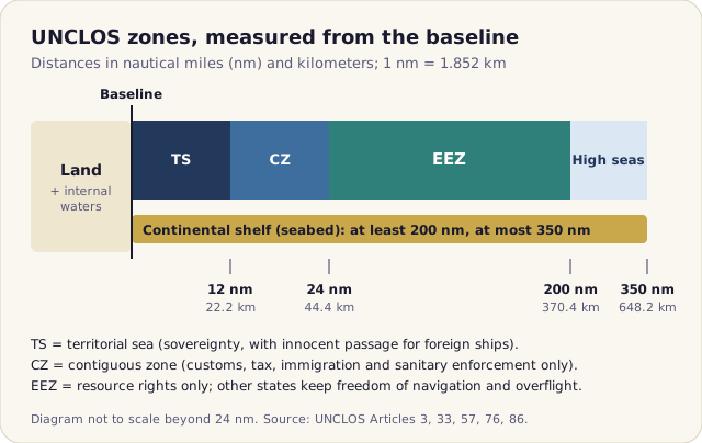
Start at the baseline
Every distance in UNCLOS is measured from the baseline. The normal baseline is the low-water line along the coast, as marked on the coastal state's official large-scale charts (Article 5). Where a coast is deeply indented or fringed with islands, as in Norway, a state may draw straight baselines joining headlands (Article 7). Water on the landward side of the baseline, such as ports, many bays and river mouths, is internal waters. Legally it is treated like land: foreign ships have no general right to enter.
The unit is the nautical mile, defined as exactly 1,852 metres. That is why the familiar round numbers turn into awkward kilometer figures: 12 nm is 22.224 km and 200 nm is 370.4 km.
The zones, one by one
| Zone | Outer limit | Coastal state has | Others keep |
|---|---|---|---|
| Internal waters (Art. 8) | baseline | Full sovereignty | No right of entry |
| Territorial sea (Arts. 2, 3, 17) | 12 nm / 22.2 km | Sovereignty over sea, seabed, airspace | Innocent passage (ships only) |
| Contiguous zone (Art. 33) | 24 nm / 44.4 km | Customs, tax, immigration, health enforcement | Navigation, overflight |
| EEZ (Arts. 56–58) | 200 nm / 370.4 km | Rights to fish, oil, gas, wind energy | Navigation, overflight, cables |
| Continental shelf (Arts. 76, 77) | 200–350 nm / 370.4–648.2 km | Seabed and subsoil only | All uses of the water above |
| High seas (Arts. 86, 87) | beyond the EEZ | Nothing | Freedom of the high seas |
Territorial sea: sovereignty, with one big exception
Out to 12 nm a state's sovereignty covers the water, the seabed and the airspace above. The exception is the right of innocent passage: ships of all states, warships included, may pass through as long as the passage is continuous and not "prejudicial to the peace, good order or security" of the coastal state (Article 19). Fishing, weapons exercises, spying and willful pollution are not innocent. Submarines must surface and show their flag (Article 20). Aircraft get no equivalent right, so a plane needs permission to fly over another country's territorial sea.
Not every state uses the full 12 nm. The United States moved from 3 nm to 12 nm only in December 1988, by Presidential Proclamation 5928.
Contiguous zone: a policing buffer
The contiguous zone reaches 24 nm from the baseline, which is only 12 nm (22.2 km) beyond the territorial sea. It is not sovereign territory. The coastal state can only act to prevent or punish breaches of its customs, fiscal, immigration and sanitary laws that happen, or are about to happen, on its land or in its territorial sea (Article 33).
Exclusive economic zone: rights to resources, not sovereignty
The EEZ is the zone that made UNCLOS matter to fishing fleets and energy companies. Out to 200 nm the coastal state has "sovereign rights" to explore and exploit natural resources, plus jurisdiction over artificial islands, marine research and environmental protection (Article 56). That wording is deliberate. The EEZ is not sovereign territory: every other state keeps the freedom to sail through, fly over and lay submarine cables and pipelines (Article 58). A foreign warship can legally cruise across another country's EEZ. A foreign trawler cannot fish there without a licence.
Continental shelf: the seabed can go further
Every coastal state gets a continental shelf of at least 200 nm. Where the natural prolongation of the land runs further, the shelf can be extended, but never beyond 350 nm from the baseline or 100 nm beyond the 2,500-metre depth contour (Article 76). Claims beyond 200 nm are submitted to the Commission on the Limits of the Continental Shelf. The rights cover the seabed and subsoil only. The water column above an extended shelf is high seas.
High seas and "the Area"
Beyond national zones lie the high seas, open to all states for navigation, overflight, fishing, cables and scientific research (Article 87). The deep seabed beyond national jurisdiction, called "the Area", and its minerals are the "common heritage of mankind" (Article 136), managed by the International Seabed Authority in Kingston, Jamaica.

The largest exclusive economic zones
Overseas territories are what put France, the United States and the United Kingdom near the top: French Polynesia, New Caledonia and the Indian Ocean islands for France, Hawaii and the Pacific territories for the US, and scattered islands such as Pitcairn and Saint Helena for the UK. Figures depend on how disputed waters, unsettled boundaries and Antarctic claims are counted, so different sources give different totals and even a different first place. The chart and table below use Wikipedia's EEZ ranking table as accessed in October 2026, which includes overseas territories and leaves out Antarctic claims. The table does not name one source for its figures.

| Rank | Country | EEZ (km²) | Area (km²) | EEZ ÷ area |
|---|---|---|---|---|
| 1 | France | 11,691,000 | 551,695 | 21.2 |
| 2 | United States | 11,351,000 | 9,833,517 | 1.2 |
| 3 | Australia | 8,505,348 | 7,692,024 | 1.1 |
| 4 | Russia | 7,566,673 | 17,098,246 | 0.4 |
| 5 | United Kingdom | 6,805,586 | 242,495 | 28.1 |
| 6 | Indonesia | 6,159,032 | 1,904,569 | 3.2 |
| 7 | Canada | 5,599,077 | 9,984,670 | 0.6 |
| 8 | Japan | 4,479,388 | 377,930 | 11.9 |
| 9 | New Zealand | 4,420,565 | 268,838 | 16.4 |
| 10 | Brazil | 3,830,955 | 8,515,767 | 0.4 |
Three caveats on those numbers:
- France or the US first? Wikipedia's article on the French EEZ, citing France's maritime-limits service (January 2023), gives 10.2 to 10.9 million km². NOAA describes the US EEZ as 3.4 million square nautical miles, which converts to about 11.66 million km² (3.4 million × 1.852²). On those national figures the US comes first.
- Lower ranks move too. A ranking compiled by Atlasocio from the Flanders Marine Institute's Maritime Boundaries Geodatabase (version 11) puts Chile 10th and Brazil 11th.
- Land area is not the driver. Russia and Canada have long Arctic coasts but rank below countries with scattered islands. The United Kingdom's EEZ is 28 times its area.
The area column is the country's total area as shown on its hoyoopin page (for France, the metropolitan area), from Wikipedia's list of countries by area. hoyoopin has no maritime or EEZ data, so the EEZ figures come from the outside sources named above.
Who is in UNCLOS, and who is not
According to the US Congressional Research Service, 170 states and the European Union had ratified the Convention as of January 2026. The best-known outsider is the United States, which never signed the 1982 Convention because it objected to the deep-seabed mining rules in Part XI, technology-transfer provisions and compulsory dispute settlement. It did sign the 1994 Agreement that revised Part XI, on 29 July 1994, but the Senate has never approved either treaty, so the US is still not a party as of October 2026. In practice the US treats most of the Convention's navigation and zone rules as customary international law: it proclaimed its own 200 nm EEZ in March 1983 (Proclamation 5030).
What landlocked countries get
There are 44 landlocked countries, from Kazakhstan, the largest by area, to doubly landlocked Liechtenstein. Part X of UNCLOS gives them a right of access to and from the sea and freedom of transit through neighbouring "transit states" (Article 125(1)). The details are not automatic. The terms must be agreed bilaterally or regionally (Article 125(2)), and transit states may take measures to protect their "legitimate interests" (Article 125(3)). Transit traffic cannot be taxed, but charges for specific services are allowed (Article 127).
Bolivia shows how this works in practice. It lost its coast to Chile in the War of the Pacific, and the 1904 treaty with Chile gives it free transit and storage facilities at Chilean ports. Bolivia still marks a "Día del Mar" every year and keeps a navy on Lake Titicaca and its rivers. In 2018 the International Court of Justice ruled that Chile has no legal obligation to negotiate sovereign sea access for Bolivia.
Quick checklist
- Measure every zone from the baseline, not from the beach or the territorial sea's edge.
- Convert with 1 nm = 1.852 km: 12 nm = 22.2 km, 24 nm = 44.4 km, 200 nm = 370.4 km, 350 nm = 648.2 km.
- Only internal waters and the territorial sea are sovereign territory. The EEZ gives resource rights, not ownership of the sea.
- Foreign ships have innocent passage in the territorial sea and freedom of navigation beyond it. Foreign aircraft need permission only over land and the territorial sea.
- When you quote an EEZ ranking, name the source and say what it includes. France and the US swap first place depending on the source.
- For a country's area, capital and population, see its country page, reachable from the search on the home page. For how countries are grouped, see our guide to UN M49 regions.
Frequently asked questions
How far do territorial waters extend?
Up to 12 nautical miles (22.224 km) from the baseline, usually the low-water line along the coast. The coastal state has sovereignty there, but foreign ships keep the right of innocent passage, meaning continuous passage that does not threaten the coastal state's peace, good order or security.
Is the exclusive economic zone part of a country's territory?
No. In the EEZ, which reaches 200 nautical miles (370.4 km) from the baseline, the coastal state has sovereign rights over natural resources such as fish, oil, gas and wind energy. Other states keep freedom of navigation, overflight and the right to lay cables and pipelines.
Which country has the largest EEZ?
It depends on the source. Wikipedia's ranking table (accessed October 2026) puts France first with 11,691,000 km² and the United States second with 11,351,000 km². National figures reverse that order: about 11.66 million km² for the US (NOAA's 3.4 million square nautical miles) against 10.2 to 10.9 million km² for France.
Has the United States ratified UNCLOS?
No. The US never signed the 1982 Convention. It signed only the 1994 Agreement revising Part XI, on 29 July 1994, and the Senate has never approved either. The US nonetheless follows most of the Convention's navigation and zone rules as customary international law and declared a 200 nm EEZ in 1983.
Sources
- United Nations Convention on the Law of the Sea (full text), United Nations, Division for Ocean Affairs and the Law of the Sea
- Exclusive economic zone, Wikipedia
- Exclusive economic zone of France, Wikipedia
- What is the U.S. Exclusive Economic Zone?, NOAA Ocean Exploration
- Implementing Agreements Under the United Nations Convention on the Law of the Sea (IF12578, January 2026), Congressional Research Service
- Landlocked country, Wikipedia
- List of countries and dependencies by area, Wikipedia